Kızılırmak River Overview
The Kızılırmak River, literally “Red River” in Turkish, is the longest river that rises and empties entirely within the borders of Turkey. It runs approximately 1,355 kilometers from the highlands of Sivas to the Black Sea at the Bafra Plain. Along the way, it carves a sweeping arc across Central Anatolia, gathers tributaries from a vast interior basin, and nourishes fertile lowlands before fanning into one of the Black Sea’s most important wetland complexes. Historically known to the Greeks and Romans as the Halys, the Kızılırmak River has served as a cultural frontier, a lifeline for agriculture, and, more recently, a backbone for hydropower and irrigation.
Today, because of its length and reach, the Kızılırmak River touches multiple provinces and landscapes: rugged volcanic plateaus, semi-arid steppes near Tuz Gölü (Lake Tuz), and the humid coastal fringe of the Black Sea. It is not navigable for commercial boats, but it is central to regional economies through water supply, fisheries, renewable energy, farming, and tourism.
Quick Facts about the Kızılırmak River Every Traveler Should Know
- Length: ~1,355 km, the longest river entirely within Türkiye.
- Basin size: ~78,180 km², the country’s second-largest drainage basin.
- Average discharge: ~128 m³/s (variable by season and year).
- Source: Slopes of Kızıldağ near İmranlı, Sivas Province (elevation ~2,000 m).
- Mouth: Black Sea near Bafra, forming the celebrated Kızılırmak Delta.
- Major tributaries: Delice, Devrez, and Gökırmak.
- Key wetland: Kızılırmak Delta, a Ramsar-listed site and UNESCO Tentative List property.
Kızılırmak River Geography and Route
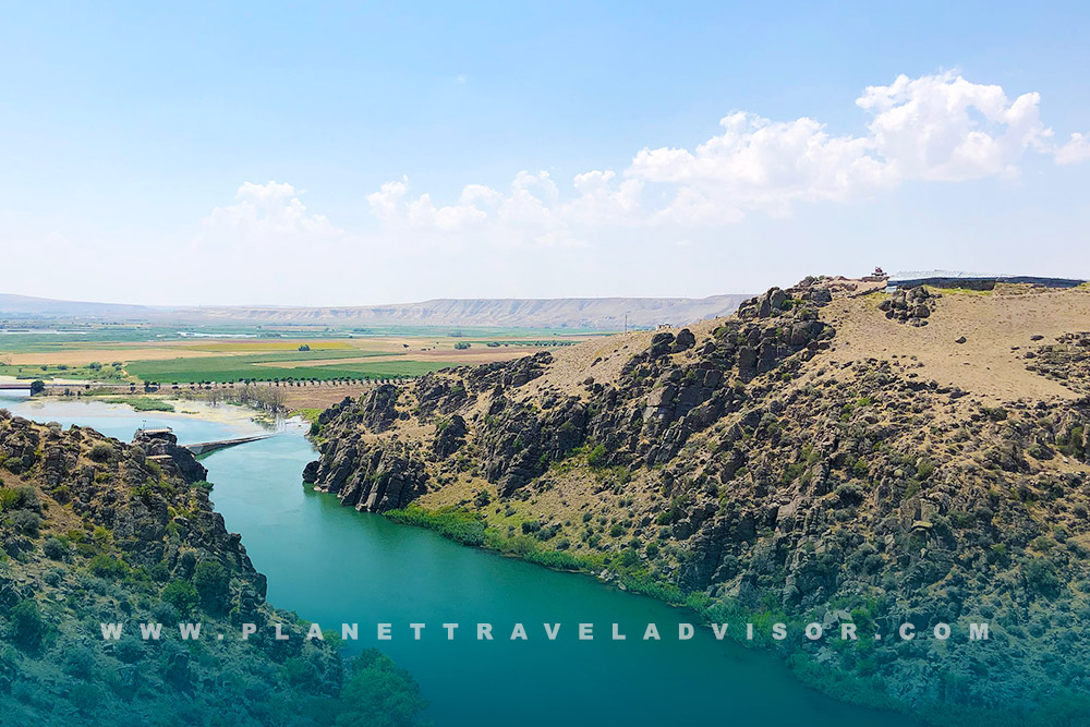
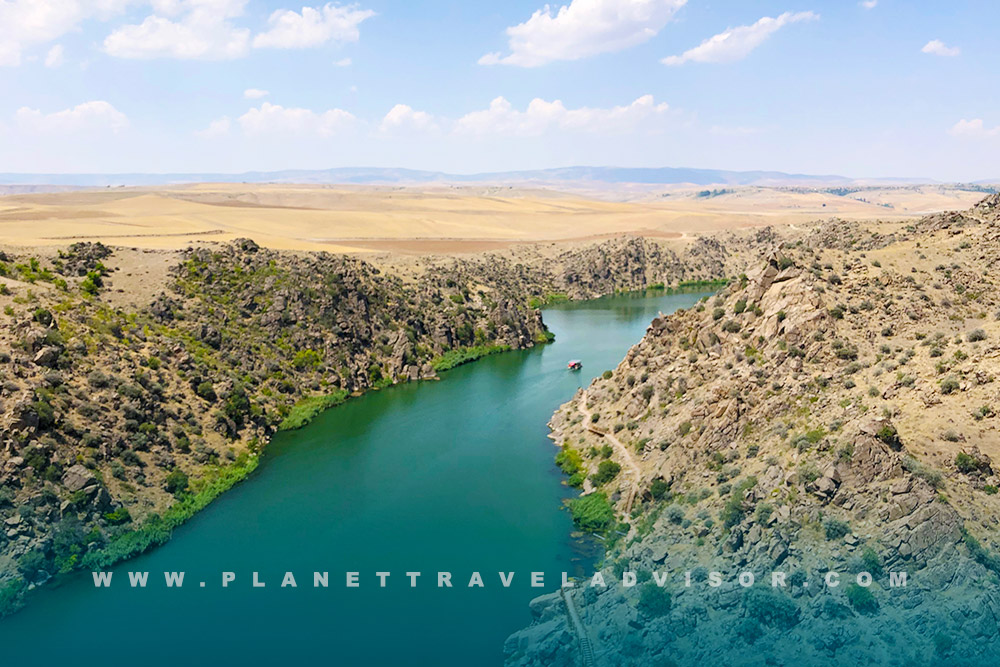
From its mountain source near İmranlı, the Kızılırmak River first flows west and southwest, then performs its signature “Halys bend,” an enormous arc that skirts the northeastern edge of Tuz Gölü. After turning north and northeast, the river collects its principal tributary, the Delice (ancient Cappadox), and later the Devrez and Gökırmak before entering the Black Sea on the Samsun coast. This grand curve defines much of the river’s geography and explains why the Kızılırmak River’s basin is so large relative to other Turkish watersheds.
Administratively, the Kızılırmak River and its basin involve many provinces. The UNESCO listing for the delta notes that the Kızılırmak River passes through Sivas, Kayseri, Nevşehir, Kırşehir, Kırıkkale, Çankırı, Çorum, and Samsun on its journey to the sea. The broader basin encompasses even more territory, reflecting the size and complexity of this watershed.
Kızılırmak River History and the Legacy of the Ancient Halys
In antiquity, the Kızılırmak River was known as the Halys, a formidable boundary in Asia Minor. Herodotus records that on May 28, 585 BCE, a sudden solar eclipse halted fighting between the Lydians and the Medes, an event sometimes called the “Battle of the Eclipse.” Although scholars debate the exact battle site, the Halys has long been associated with the frontier where peace was brokered and royal marriages sealed. The episode shows how the Kızılırmak River (Halys) was perceived not just as a physical barrier but as a symbolic frontier between powers.
Later, during the Roman and Byzantine periods, the Halys continued to feature in routes and campaigns, while in the Seljuk era, iconic crossings appeared, including the Kesikköprü Bridge (built 1248 under Kaykaus II) that still spans the Kızılırmak River in Kırşehir Province, a testament to medieval engineering aligned with strategic riverine corridors.
Kızılırmak River Tributaries and Basin Dynamics
The Kızılırmak River owes its power and breadth to a network of tributaries draining a diverse interior. The Delice River joins from central Anatolia, while the Devrez and Gökırmak descend from more northerly uplands. Combined, they contribute to a ~78,180 km² basin, Türkiye’s second largest, which supports agriculture, towns, and industry. Hydrologically, the basin’s rainfall regime varies widely from continental interiors to the Black Sea’s maritime fringe, producing pronounced seasonality in flows and occasionally challenging extremes such as drought or flood.
Because the Kızılırmak River is not navigable, its economic role comes primarily from irrigation, hydropower, groundwater recharge, fisheries, and ecosystem services. Notably, historical and ongoing land-use and water management practices upstream influence sediment delivery to the coast, which in turn shapes delta growth and coastal stability.
Delta and Wildlife of the Kızılırmak River
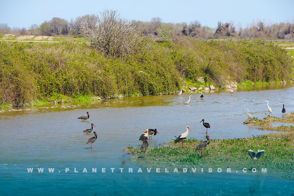
At the Black Sea, the Kızılırmak River spreads into an impressive delta system often called the Bafra Delta or Kızılırmak Delta. The broader delta covers roughly 56,000 hectares, while the formally designated Ramsar site protects about 21,700 hectares of dunes, lagoons, seasonal marshes, reedbeds, and forests. These habitats host globally significant bird populations on migration and in winter.
According to Ramsar documentation, over 92,000 waterbirds winter here in some years. The delta is also important for breeding, with surveys reporting at least 140 breeding bird species. The site’s value is recognized not just by Ramsar but also through its presence on the UNESCO World Heritage Tentative List as the “Kızılırmak Delta Wetland and Bird Sanctuary.”
Biodiversity is not limited to birds. The Kızılırmak River estuary and delta support fish such as carp and zander; historical records and conservation notes mention rare and endangered sturgeon species (e.g., fringebarbel and stellate sturgeon) that still appear in the estuary. These occurrences underscore the delta’s role as a potential lifeline for anadromous fish in the Black Sea region.
For travelers, the Kızılırmak River delta is a premier birdwatching destination, with observation towers and seasonal spectacles of migration. Sensitive access rules exist to protect nesting and feeding areas. Visitors should follow local guidance and seasonal restrictions for the best experience and to minimize disturbance.
Dams and Modern Water Management of the Kızılırmak River
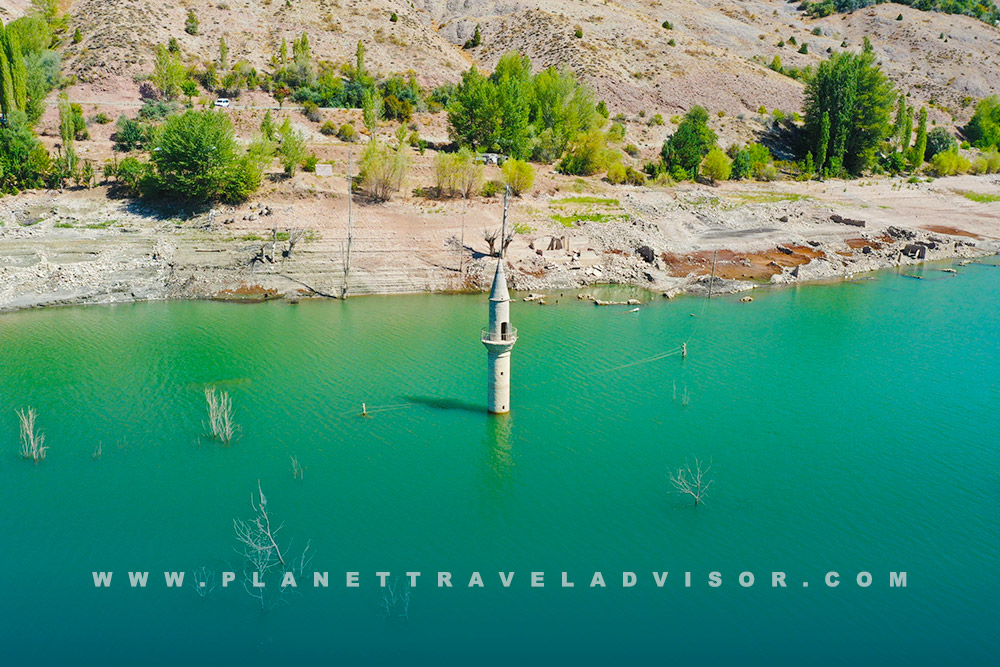
Over the last seven decades, a chain of dams and reservoirs has transformed the Kızılırmak River into one of Türkiye’s key renewable energy and irrigation systems. The portfolio includes both early state-built projects and recent large private investments.
- Hirfanlı Dam and HEPP (completed 1959): a landmark, 78 m-high multi-purpose project in Kırşehir Province, installed capacity ~128 MW and typical annual generation ~300–400 GWh.
- Kesikköprü Dam and HEPP (1966): ~76 MW near Ankara, an important irrigation and power scheme on the Kızılırmak River.
- Kapulukaya Dam and HEPP (1989): ~54 MW near Kırıkkale, integral to regional water supply and energy.
- Altınkaya Dam and HEPP (1988): one of the basin’s giants near Bafra in Samsun Province; rock-fill dam ~195 m high with an installed capacity of ~700 MW (4×175 MW).
- Derbent Dam and HEPP (1990): downstream of Altınkaya, ~56–58 MW installed, contributing ~257 GWh annually.
- Boyabat Dam and HEPP (2012): a 195 m-high concrete gravity dam between Sinop and Samsun Provinces; installed capacity ~513 MW with ~1.5 TWh average annual generation.
Together, these and other Kızılırmak River projects supply clean electricity, regulate floods, and sustain irrigation networks that underpin agriculture in central Anatolia. However, they also alter the timing and magnitude of flows and reduce sediment moving to the delta, a key factor behind shoreline change and wetland dynamics in the Kızılırmak River mouth area. Sustainable management now balances hydropower and irrigation benefits with ecological integrity downstream.
Travel Planning Tips for Kızılırmak River
While no commercial cruises operate on the Kızılırmak River, it still offers rich experiences for travelers who enjoy culture and nature. The best approach is to visit a handful of distinct river segments, each with its character.
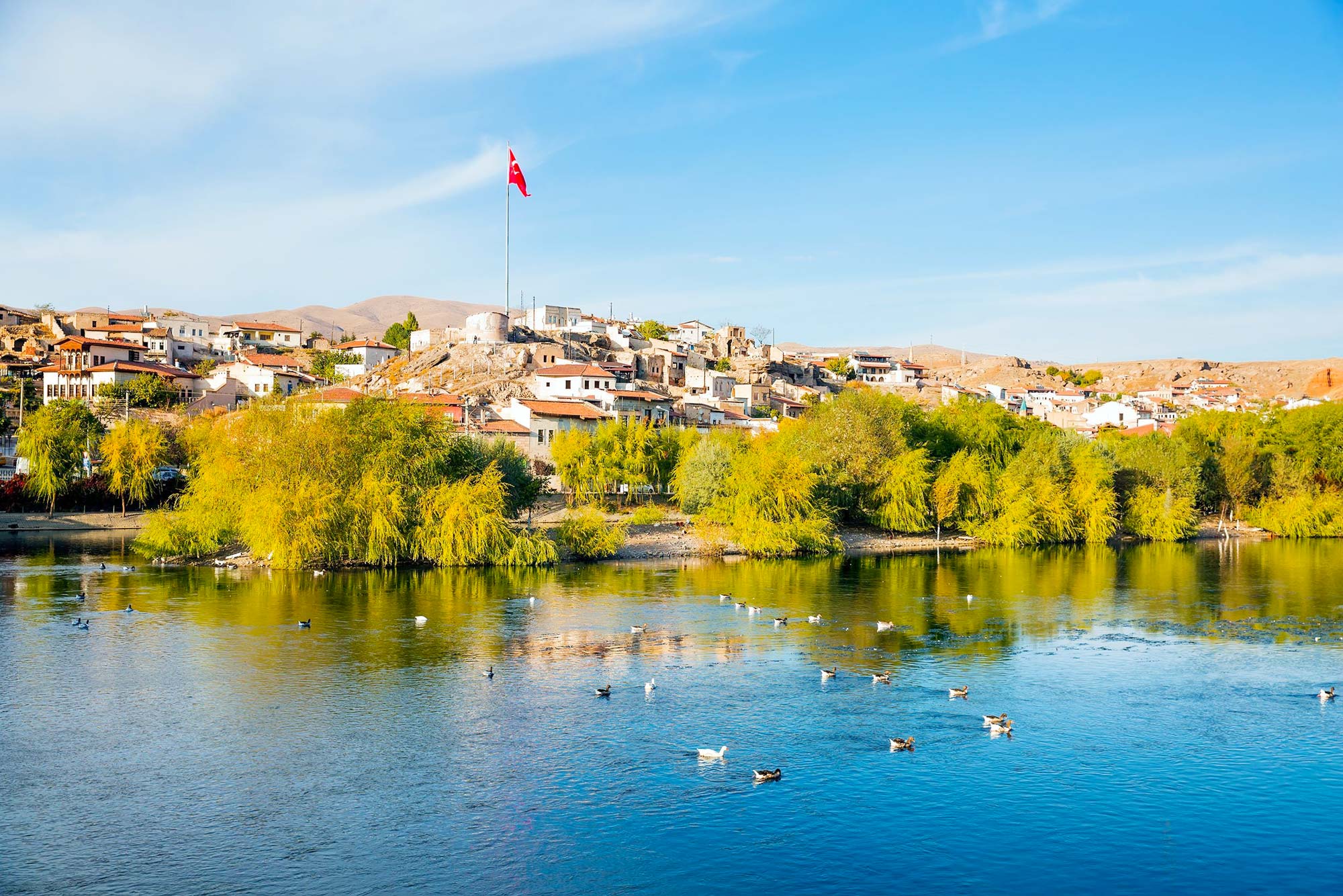
Kızılırmak River in Cappadocia and Avanos Experiences
Base yourself in Cappadocia to combine fairy chimneys and underground cities with riverfront Avanos. Stop into pottery studios, stroll the river promenade, and, in season, look for gentle on-water experiences such as guided flatwater rides or canoe and gondola-style outings within the sheltered canyon and town reaches where permitted. These are short excursions focused on sightseeing rather than long-distance paddling.
Kızılırmak River Delta Birding Window
For birding at the Kızılırmak River delta, peak migration typically occurs in spring and autumn, while winter brings impressive assemblages of waterbirds to the lagoons and reedbeds. Check local visitor centers for access points, observation towers, and seasonal closures; dawn and dusk often yield the most activity.
Kızılırmak River Heritage Stops Inland
Consider brief inland detours to the Kesikköprü Bridge in Kırşehir Province for Seljuk-era masonry over the Kızılırmak River, and to scenic overlooks near the Hirfanlı Reservoir for big-sky steppe views and lakeside recreation areas popular with local families.
Finally, Experience Turkey like never before with expertly curated tours made for explorers at heart. Stroll through colorful markets alive with history, gaze over Cappadocia’s otherworldly landscapes, and trace the footsteps of ancient civilizations in Ephesus. Every itinerary blends comfort, authenticity, and unforgettable sights. Secure your journey today to unlock special savings and priority booking on our best-selling Turkey tours 2026. History, flavor, and discovery are waiting.